

The Fisheries Oceanography Lab in the Oceanography Department at Dalhousie University began in 1999 devoting some research effort toward addressing the plight of the North Atlantic right whale. The work of Dr. Christopher Taggart and his colleagues and graduate students is, or has been, focused in five general areas of research, some of which are summarized here.
Whale Sounds
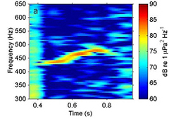
An example spectrogram of a typical
upsweeping right whale sound lasting
about half a second with a mean peak
frequency 459Hz.
The Fisheries Oceanography Lab began their earliest research on right whale sounds for the purposes of advancing real-time localization of right whales in the Bay of Fundy. They were able to show that the sounds produced by the whales are detectable and contain distinct characteristics that can be measured and passive (just listening) acoustic-location of right whales in the lower Bay of Fundy is both feasible and informative 1, 2, 3.
Whales and Vessel-Strikes
More recently, the Dalhousie team has determined the likelihood of a right whale or another large whale being killed from a vessel strike according to the speed of the vessel. Their results show that right whales appear to be more prone to vessel strikes than other large whales. In addition, large vessels traveling at speeds of more than 28 km/h (15 knots) will almost assuredly kill a large whale; at speeds of 15 km/h (8 knots) or less the chances of the whale being killed are 1 in 5 or less 4. This kind of research can be used to assess the effectiveness of vessel speed-limits that are being proposed around the world.
This graph illustrates the likelihood of a large whale being killed if struck by a large vessel moving at speed. At speeds of 28 km/h (15 knots) or more, the chances of being killed rise from around 80% to 100%. At around 22 km/h (12 knots), there is, on average, a 50% chance of being killed. It is only below 15 km/h (8 knots) of vessel speed that the chances of being killed fall below 20% and approach zero near 3.7 km/h (2 knots).
Vessel and Whale Encounters
Researchers at Dalhousie University have been working for some time to estimate encounter probabilities between vessels and right whales, especially in regions where they aggregate to feed, such as the lower Bay of Fundy and the Roseway Basin on the Scotian Shelf. Their work in the Bay of Fundy, along with others at the Canadian Whale Institute, helped show that a slight shift of the internationally adopted shipping lanes would decrease the probability of a vessel striking a right whale.
A chart of the Bay of Fundy showing where vessel and right whale encounters would be highest (dark red) in the shipping lanes before (red dashed line) they were shifted slightly to the east (green lines). The central black rectangle outlines the Grand Manan Basin Right Whale Conservation Area.
Similar work has recently been completed in the Roseway Basin Conservation Area. The results have helped collaborators at the Canadian Whale Institute determine the boundaries of an area to be avoided by vessels that is currently being considered by the international shipping community. If adopted, vessels would be encouraged to avoid the area and minimize the probability of a vessel striking a right whale.
The Fisheries Oceanography Lab is now collaborating with other researchers in the United States, including the University of Delaware, to use these kinds of analyses along the entire eastern seaboard of Canada and United States.
This chart shows where most of the vessel traffic navigates in the area around the Roseway Basin Conservation Area (small dashed line rectangle). There are three to six times as many vessels to the north (4-6 contours) of the right whale habitat than there are in the habitat (1-2 contours). Thus, having vessels avoid the area noted by the red polygon will only affect an average of 16 to 30% of most vessels and avoiding the area will not cause a major deviation in their travels.
Whales and Fishing Gear Encounters
In a manner similar to that of the vessel and whale encounter studies, Dr. Christopher Taggart's team has been working with colleagues at Fisheries and Oceans Canada St. Andrews Biological Station to estimate encounter probabilities between right whales and fixed fishing gear, especially in those regions through which the whales must migrate and those where they aggregate to feed. These kinds of analyses can be used to modify fishing practices in time and space to the benefit of the right whales (reduced entanglements) and with minimum impact on the fishing industry.
Bathymetric chart of the Scotia-Fundy and Gulf of Maine region illustrating (expanding symbols) number of fixed fishing-gear sets (groundfish gillnets, hook & line, and crab traps/pots) aggregated over the period 1999-2005. Red rectangles outline the two North Atlantic right whale conservations areas. Right whales are known to travel back and forth between these two areas within a season.
Whales and Their Food
During summer and fall, in the Grand Manan Basin Conservation Area, as many as two-thirds of the known right whales feed on the resting stage of the copepod Calanus finmarchicus. Scientists in the Fisheries Oceanography Lab have determined the spatial and temporal variation in whale food and its energy content. This can be used to help explain variation in the health of the right whales, their reproductive capacity and the carrying capacity of their feeding habitat. Results shown that food energy density in the Grand Manan Basin reaches a maximum in late summer when the right whales are most abundant. It has been estimated that the habitat area can support the energy demands of as many as 200 whales for a period of 95 days, though there is much variation in time and space 5.
In collaboration with colleagues at the St. Andrews Biological Station, they are planning to make similar measurements in Roseway Basin, another primary right whale feeding habitat area.
This graph shows that when the number of whales, the concentration of their food, and the total food-energy in the basin are measured on the same scale (0-1), the whales occupy the basin in proportion to the food available.
* Dr. Christopher T. Taggart and his colleagues and graduate students at Dalhousie University would like to recognize the support of several funding agencies whom they thank for their generous contributions: Canadian Whale Institute, Government of Canada Habitat Stewardship Program for Species at Risk, NOAA Fisheries Service, Endangered Species Recovery Fund, Fisheries and Oceans Canada, and the Natural Sciences and Engineering Research Council of Canada. They also thank the North Atlantic Right Whale Consortium and in particular the researchers at the New England Aquarium for data sharing and field support.
1 Desharnais, F., A. Vanderlaan, C. Taggart, M. Hazen and A. Hay. 1999. Preliminary results on the acoustic characterization of the Northern right whale. Journal of the Acoustical Society of America 106:2163.
2 Laurinolli, M. H, A. E. Hay, F. Desharnais and C. T. Taggart. 2003. Localization of North Atlantic right whale sounds in the Bay of Fundy using a sonobuoy array. Marine Mammal Science 19:708-723. [pdf]
3 Vanderlaan, A. S. M., A. E. Hay, and C. T. Taggart. 2003. Characterisation of North Atlantic right whale (Eubalaena glacialis) sounds in the Bay of Fundy. IEEE Journal of Oceanic Engineering 28:164-173. [pdf] Strathroy Bathroom Renovation
4 Vanderlaan, A. S. M. and C. T. Taggart. 2007. Vessel collisions with whales: the probability of lethal injury based on vessel speed. Marine Mammal Science 23:144-156. [pdf]
5 Michaud, J. and C. T. Taggart. 2007. Lipid and gross energy content of North Atlantic right whale food, Calanus finmarchicus, in the Bay of Fundy. Endangered Species Research 3:77-94. [pdf] website
