

Monitoring the status and changes in the right whale species is critical to determining population parameters and trends, which are used for developing management strategies and evaluating their effectiveness at reducing mortality.
Systematic surveys are the major research method used to monitor the right whale population. They allow researchers to collect sightings of the population in an area of interest. Researchers on boats and airplanes follow systematic survey lines also known as transect or track lines. These are parallel lines with a set distance between them covering the entire survey area. During shipboard surveys, the survey crew usually consists of two observers scanning the port and starboard quarters out to a nominal distance of at least 4 km. The vessel travels on north-south survey lines set 5 - 9 km apart depending on the height of the observers above water.
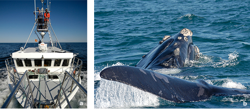
a) Researchers on watch during a systematic survey in the Gulf of St. Lawrence.
b) Shipboard view of a North Atlantic right whale posturing (lifting head and tail out of the water at the same time).
The vessel moves at about 20 km/h (11 knots) when visibility is ≥ 4 km and in sea state ≤ 4 (see Beaufort scale). All whales sighted are identified, counted and the vessel location recorded using a Global Positioning System (GPS) when the ship is abeam of the sighting location. When right whales are encountered the vessel stops and approaches to obtain photographs, then returns to the track line and resumes the survey on the previous heading. Aerial surveys are conducted in a similar manner while flying at a speed of 180 km/h (100 knots) and at an altitude of 230 - 305 m. They are usually flown in an east-west direction to reduce the effects of solar glare. Survey lines are spaced at 3 - 9 km intervals depending on the purpose of the survey. As is done during vessel surveys, the aircraft breaks the trackline for photographs when right whales are encountered, then resumes the survey where it left off.
a) A Cessna Skymaster 337 aerial survey plane photographed while in flight.
b) Two researchers are scanning for right whales during an aerial survey over Roseway Basin. c) A group of three right whales as seen from the survey plane.
The New England Aquarium (NEAq) and other collaborators have conducted surveys in the waters of the lower Bay of Fundy between Nova Scotia and New Brunswick and on Roseway Basin south of Nova Scotia in the summer and fall since 1980. The information compiled in the photographic catalogue and sightings database with survey data from Canadian waters, in combination with survey data from the three critical habitat areas in U.S. waters, serves multiple science and conservation purposes. For example, aerial and shipboard surveys are used to count animals including calves, collect information on population status, monitor animal's health, and assess scarring. These data are presented in meetings to assist in the development of right whale recovery strategies, and are used by government managers in Canada and the United States to determine trends, relative risk, and the effectiveness of management measures. In 2006, shipboard surveys were expanded to include the waters south of the Gaspé Peninsula. The survey work was carried by the Canadian Whale Institute, the Centre d’Études et de Protection de la Baleine Noire du Saint-Laurent and the New England Aquarium. Surveys are needed in this lesser known right whale habitat area to determine their distribution, patterns of habitat use, and potential threats from human activities.
